




Discover Jharsuguda – The Powerhouse of Odisha
Discover Jharsuguda – The Powerhouse of OdishaJharsuguda is a vibrant and rapidly developing district in western Odisha, known for its strong industrial foundation, rich cultural heritage, natural beauty, and excellent connectivity. Often recognized as an important industrial and energy hub, Jharsuguda plays a significant role in the economic growth of Odisha.The district is home to major industries and power-related activities while also offering beautiful landscapes, historic places, temples, rivers, and cultural attractions. Its combination of industrial progress and natural heritage makes Jharsuguda a unique destination in Odisha.With growing infrastructure, improved transportation, modern facilities, and expanding opportunities, Jharsuguda continues to move forward while preserving its cultural identity and traditions.Jharsuguda
A District of Energy and Industry
Jharsuguda is particularly famous for its abundant coal and mineral resources and its concentration of power and industrial projects. The availability of natural resources has played an important role in the district’s economic development.Over the years, the region has attracted major industries connected with power generation, coal, aluminium, iron and steel and other industrial activities. This strong industrial ecosystem has helped Jharsuguda become one of Odisha’s important economic and employment centres.The district’s industrial identity is complemented by its growing infrastructure, transportation facilities and connectivity, making Jharsuguda an important gateway to western Odisha.
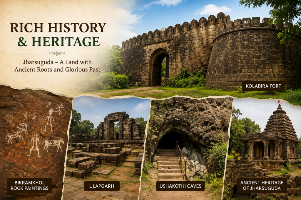
Rich History and Heritage
Jharsuguda has a fascinating historical background. The district was carved out of the former Sambalpur district and became a separate district in 1994. Its history is closely connected with the former zamindari regions of Rampur, Kolabira, Padampur and Kudabaga.The district also preserves archaeological and historical remains that reflect the region’s ancient settlements and cultural development. Sites such as Bikramkhol, Ulapgarh, Ushakothi caves and Kolabira Fort add an important historical dimension to Jharsuguda.The district also preserves archaeological and historical remains that reflect the region’s ancient settlements
Demographics & Statistics

Total Population
579,505

Geographical Area
2,081 km²

Literacy Rate
78.86%

Population Density
274 persons/km²
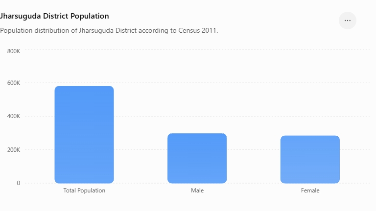
District Population Chart
Jharsuguda District is one of the important districts of Odisha, known for its growing urban centres, industrial development and diverse communities. According to the Census of India 2011, the district recorded a total population of 579,505. This population includes 296,690 males and 282,815 females, reflecting a fairly balanced demographic composition.The district has experienced considerable demographic and economic development over the years. The growth of industries, expansion of urban areas and improved connectivity have contributed to the increasing importance of Jharsuguda as a regional centre.
Administrative Divisions of jhasuguda District

Jharsuguda
Jharsuguda is the district headquarters and an important urban, administrative and commercial centre.

Lakhanpur
Lakhanpur is an important rural and industrial area of the district, known for its natural resources.

Kolabira
Kolabira is predominantly a rural area where agriculture and activities form an important part of the local economy

Kirmira
Kirmira is a rural and agriculturally important tahasil, with villages, farmland and local communities .

Laikera
Laikera is known for its rural landscape, agriculture and forest resources. The area represent.

Belpahar
Belpahar is an important industrial and residential town associated with the coal and power sectors.
Demographics Charts
| Demographic Indicator – Jharsuguda District | Data |
|---|---|
| Total Population | 5,79,505 |
| Male Population | 2,96,690 |
| Female Population | 2,82,815 |
| Rural Population | 3,48,340 |
| Urban Population | 2,31,165 |
| Geographical Area | 2,114 sq. km |
| Population Density | 274 persons/sq. km |
| Population Growth (2001–2011) | 13.69% |
| Sex Ratio | 953 females/1,000 males |
| Average Literacy Rate | 78.86% |
| Male Literacy Rate | 86.61% |
| Female Literacy Rate | 70.73% |
| Child Population (0–6 years) | 64,794 |
| Literate Population | 4,05,879 |
| Total Villages | 352 |
| Administrative Blocks | 5 |
Jharsuguda District Measurements
| District Measurement Indicator | Data |
|---|---|
| Geographical Area | 2,114 sq. km |
| North–South Extent | Approx. 56 km |
| East–West Extent | Approx. 50 km |
| Population Density | 274 persons/sq. km |
| Total Population | 5,79,505 |
| Rural Area | Predominantly rural settlements |
| Urban Area | Major towns and urban centres |
| Number of Blocks | 5 |
| Number of Tehsils | 5 |
| Number of Villages | 352 |
| Number of Gram Panchayats | 78 |
| Number of Urban Local Bodies | 5 |
| District Headquarters | Jharsuguda |
| Major River | Ib River |
| Major Industrial Area | Jharsuguda–Belpahar Industrial Region |
Previous History of Jharsuguda District
| Historical Period / Event | Details |
|---|---|
| Ancient Period | The region formed part of the wider cultural and historical landscape of western Odisha. |
| Early Settlements | Local communities developed settlements supported by agriculture, forests and traditional occupations. |
| Sambalpur Region | Jharsuguda remained historically connected with the former Sambalpur administrative region. |
| Princely State Period | The area developed under the historical administration associated with the Sambalpur region and local zamindari system. |
| British Period | Railway development and improved transportation increased the importance of Jharsuguda as a commercial and transport centre. |
| Railway Development | Railway connectivity encouraged movement of people, goods and agricultural products and supported urban growth. |
| Post-Independence Period | After 1947, development of roads, public institutions, transport and industries contributed to the region’s modernization. |
| Industrial Development | Coal, power, aluminium and mineral-based industries gradually became major contributors to the district’s economy. |
| District Formation | Jharsuguda was separated from the former Sambalpur District and became a separate district on 1 January 1994. |
| Modern Development | The district has developed into an important industrial and transportation hub of western Odisha. |
| Present Importance | Jharsuguda is known for its industrial infrastructure, railway connectivity, airport and strategic location in western Odisha. |
Revenue Administration of jharusguda District.
| Revenue Administration Indicator | Details |
|---|---|
| District Headquarters | Jharsuguda |
| Revenue Sub-Divisions | 1 – Jharsuguda |
| Revenue Tahasils | 5 |
| Revenue Circles | 18 |
| Blocks | 5 |
| Gram Panchayats | 78 |
| Revenue Villages | 352 |
| Urban Local Bodies | 5 |
| District Revenue Authority | Collector & District Magistrate |
| Sub-Divisional Authority | Sub-Collector, Jharsuguda |
| Tahasildar | Head of Revenue Administration at Tahasil level |
| Revenue Administration Functions | Land records, land revenue, mutation, certificates, encroachment control and disaster-related revenue work |
| Land Records Management | Maintenance and updating of land and property records |
| Revenue Services | Issuance of various revenue certificates and land-related services |
| Administrative Objective | Efficient management of land, revenue resources and citizen-oriented services |
